Wind
5 km/h
aus O · 1 Bft
Böen bis 9 km/h
↑


 15°
0%
↑5 km/h
15°
0%
↑5 km/h
14°
0%
↑5 km/h
14°
0%
↑5 km/h
14°
0%
↑5 km/h
14°
0%
↑5 km/h
14°
0%
↑6 km/h
14°
0%
↑5 km/h
16°
0%
↑4 km/h
18°
0%
↑4 km/h
19°
0%
↑6 km/h
20°
0%
↑7 km/h
20°
0%
↑6 km/h
20°
9%
↑6 km/h
20°
9%
↑6 km/h
20°
0%
↑5 km/h
19°
0%
↑4 km/h
18°
0%
↑4 km/h
15°
0%
↑5 km/h
15°
0%
↑5 km/h
14°
0%
↑5 km/h
14°
0%
↑5 km/h
14°
0%
↑5 km/h
14°
0%
↑5 km/h
14°
0%
↑6 km/h
14°
0%
↑5 km/h
16°
0%
↑4 km/h
18°
0%
↑4 km/h
19°
0%
↑6 km/h
20°
0%
↑7 km/h
20°
0%
↑6 km/h
20°
9%
↑6 km/h
20°
9%
↑6 km/h
20°
0%
↑5 km/h
19°
0%
↑4 km/h
18°
0%
↑4 km/h
 17°
0%
↑4 km/h
17°
0%
↑3 km/h
17°
0%
↑4 km/h
16°
0%
↑5 km/h
16°
0%
↑4 km/h
16°
0%
↑4 km/h
17°
0%
↑4 km/h
17°
0%
↑3 km/h
17°
0%
↑4 km/h
16°
0%
↑5 km/h
16°
0%
↑4 km/h
16°
0%
↑4 km/h
| Quelle | Max / Min | Regen |
|---|---|---|
| Vorhersage | 20° / 14° | 0.0 mm |
| DHMZ | 23° / 14° | 0.0 mm |
| WetterOnline | 21° / 14° | 0 % |
| Quelle | Max / Min | Regen |
|---|---|---|
| Vorhersage | 20° / 15° | 0.0 mm |
| DHMZ | 22° / 12° | 0.0 mm |
| WetterOnline | 21° / 14° | 60 % |
| Quelle | Max / Min | Regen |
|---|---|---|
| Vorhersage | 20° / 18° | 19.1 mm |
| DHMZ | 17° / 14° | 22.7 mm |
| WetterOnline | 22° / 18° | 80 % |
| Quelle | Max / Min | Regen |
|---|---|---|
| Vorhersage | 18° / 13° | 11.2 mm |
| DHMZ | 14° / 9° | 4.1 mm |
| WetterOnline | 19° / 16° | 80 % |
| Quelle | Max / Min | Regen |
|---|---|---|
| Vorhersage | 18° / 12° | 2.2 mm |
| DHMZ | 14° / 6° | 0.1 mm |
| WetterOnline | 20° / 14° | 0 % |
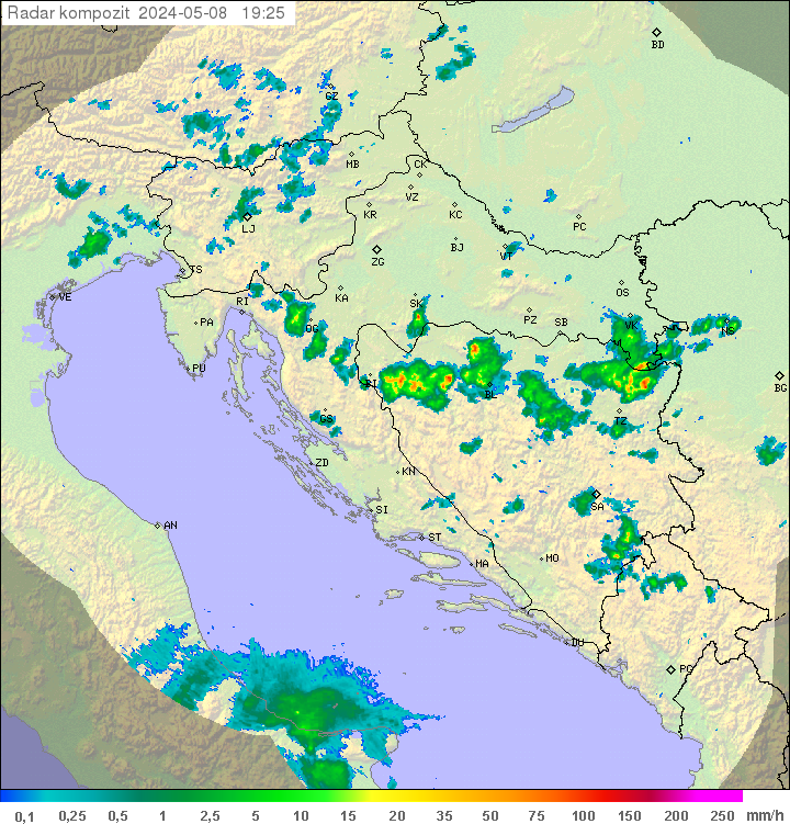
Erstes Bild: Radar jetzt. Danach 24 Stunden Vorschau aus dem ICON-Modell.
Quelle: DHMZ · Niederschlagsintensität in mm/h, Zeitstempel im Bild (UTC+2).
Blitzortung.org zeigt Live-Ortungen, ist aber keine Unwetterwarnung. Beim Laden erhält der Betreiber deine IP-Adresse. Maßgeblich sind die amtlichen Warnungen des DHMZ.
During the night in the North Adriatic risk of fog.
A field of high keeps staying across the Adriatic.
Calm or variable winds up to 10 knots. The sea 1-2, in the open of the Central and South Adriatic 2-3. Visibility of about 20 km. Mostly clear, locally fair skies, in the North and in a part of the Central Adriatic increased cloudiness.
Calm or light variable winds. The sea calm or smooth. During the night in the North Adriatic fog locally. Fine to fair skies.
Weather report issued by The Marine Meteorological Center Department Split on 17.10.2026 at 12
During the night in the North Adriatic risk of fog.
Median und stärkste Böe eines Modells.
Median und Spannweite der Modelle.
Menge und Wahrscheinlichkeit.
Tagesmittel aus dem Open-Meteo-Marine-Archiv (Reanalyse).
| Jahr | Ø | wärmster Tag | kältester Tag | Tage ≥ 20 °C |
|---|
Zielzeit: Mo 13:00 · Wind und Böen in km/h.
| Modell | Temp | Wind | Böen | Richtung | Regen |
|---|---|---|---|---|---|
| ICON (DWD) | 20.5° | 6 | 7 | SSW | 0.0 mm |
| GFS (NOAA) | 19.4° | 7 | 3 | WNW | 0.0 mm |
| IFS HRES 9 km (ECMWF) | 20.3° | 6 | 20 | W | 0.0 mm |
| ARPEGE Europe (MF) | 21.0° | 5 | 15 | NW | 0.0 mm |
| UM (UK Met Office) | 17.3° | 5 | 11 | W | 0.0 mm |
| GEM (Kanada) | 19.1° | 6 | 6 | WSW | 0.0 mm |
| GSM (Japan) | 22.3° | 2 | – | NO | 0.0 mm |
| AIFS (ECMWF) | 18.9° | 4 | – | WSW | 0.0 mm |
| HARMONIE 2 km (DMI) | 20.2° | 12 | 22 | SW | 0.0 mm |
| ICON-2I 2,2 km (ItaliaMeteo) | 20.5° | 6 | 14 | SSW | 0.0 mm |
| MET Norway (Locationforecast) | 20.4° | 8 | – | WSW | 0.0 mm |
| WetterOnline | 20.0° | 5 | 10 | SW | – |
| Ensemble-Median | 20.2° | 6 | 11 | – | 0.0 |
Version 0.1.40
Wetterdaten: Open-Meteo (CC-BY 4.0), MET Norway (NLOD/CC-BY 4.0), WetterOnline und DHMZ. Radar: RainViewer. Karte: Esri und © OpenStreetMap-Mitwirkende. Wetter-Icons: Bas Milius (MIT).